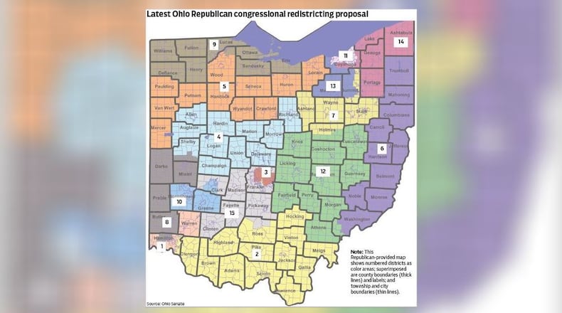
Koehler said he voted against the map because it splits Springfield off from most of the rest of Clark County. Residents told him they strongly oppose that split, he said.
“I’ve never had all of my constituents agree on one topic before,” Koehler said.
An arc of the county east, north and west of Springfield is in the new District 15, which includes Columbus suburbs and several other counties to the south.
It’s understandable and necessary to split large urban counties, but there’s no reason to do the same to Clark, which has about 130,000 people, Koehler said.
The map’s new District 10 keeps together Montgomery and Greene counties and adds a chunk of Clark County, putting Wright-Patterson Air Force Base and the Springfield Air National Guard base in the same district.
U.S. Rep. Mike Turner, R-Dayton, now represents the area that includes Wright-Patt and said previously he’s long been an advocate for the base, which is Ohio’s largest single-site employer with nearly 30,000 workers. His office declined to comment Thursday on the impact of having Wright-Patt and the Springfield base in the same district.
Dayton Mayor Nan Whaley and several progressive and voting rights groups called on DeWine to veto the map. Whaley, a Democrat running for governor, said DeWine pledged in 2018 to support a bipartisan redistricting process.
“The rules are pretty clear — the voters said that the redistricting process should be done in a bipartisan way and when I am governor, there will be an expectation that the new district maps honor the voters’ wishes,” she said in a news release.
Dan Tierney, press secretary for DeWine, said the governor’s office was not likely to comment until officially receiving the bill, which would probably not take place the same day it passed.
Legislators debated for two hours, but their speeches largely repeated testimony from many hours of committee hearings. Democrats argued that the map is gerrymandered to increase Republican dominance by splitting urban and minority communities. Republicans asserted that the map is fair and meets all legal requirements.
State Rep. Willis E. Blackshear Jr., D-Dayton, voted against the new congressional districts and sent a letter to DeWine urging him to veto it.
“Ohioans in 2015 and 2018 overwhelmingly voted for a fair and transparent redistricting process. When you look at the current Congressional map, it isn’t a true representation of Ohio,” Blackshear said.
State Rep. Emilia Sykes, D-Akron, raised the prospect of a public referendum to repeal the map, as happened in 2011 with legislation limiting collective bargaining.
The office of House Speaker Bob Cupp, R-Lima, released a statement after the vote.
“The congressional map approved today is fair, thoughtful and most importantly, constitutional. It ensures all Ohioans have a voice in Washington,” the news release said. It rejected accusations of gerrymandering and lack of public input.
A major point of contention is a three-way split of Hamilton County. Though the city limits of Cincinnati are kept within one district, other areas with large minority populations are attached to two districts that are much more rural, white and conservative.
“How are these people actually able to elect representatives of their choice?” said state Rep. Brigid Kelly, D-Cincinnati.
The map, passed as substitute Senate Bill 258, was sponsored by Sen. Rob McColley, R-Napoleon. He said it splits only 12 of Ohio’s 88 counties, with only two of them split twice: Hamilton and Cuyahoga.
That’s fewer than Democratic maps, and the fewest splits in more than 50 years, McColley said.
“This map has six seats that lean Republican, seven seats that are competitive, and two seats that lean Democrat,” he said. All the districts deemed competitive have a partisan difference no greater than 8%, McColley said during the Senate debate.
Ohio’s 16 current House seats are occupied by 12 Republicans and four Democrats. Due to results of the 2020 census, Ohio must lose one House seat.
Since it passed by a simple majority vote without Democratic support, the map must be redone in four years. To last for a decade, a map would have to get a three-fifths overall majority and support from one-third of Democrats.
About the Author

