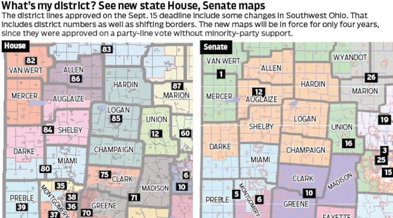
If they can craft one that garners a three-fifths overall majority and support from one-third of Democrats, it will be valid for a decade. If not, they can accept a map by simple majority vote without bipartisan support, but it would have to be redone in four years.
Lawmakers held several hours of committee hearings Thursday on the three current proposals — in the Ohio Senate, Democrats and Republicans have each released a map; while in the Ohio House, Republicans have put forth a plan.
Senate Democrats released their map proposal Sept. 29. Both Republican maps were released on Wednesday. Several speakers Thursday said they had not had time to analyze Republican proposals in detail, or that their planned testimony changed abruptly after a look at the Republican-backed maps.
State Rep. Phil Plummer, R-Butler Twp., is a member of the House Government Oversight Committee and participated in the five-hour hearing on Thursday. He said the extensive public testimony so far has seemed one-sided.
Credit: FILE
Credit: FILE
“Taking their comments very seriously, of course,” Plummer said.
For himself, Plummer withheld comment on the maps, saying he hasn’t yet had a chance to go through the Senate Republican proposal and is still going through the House version.
It’s too early in the process to tell how things will play out, or if the proposals will be significantly amended, he said.
“We’re hoping to get a 10-year map. I don’t know if that’s possible,” Plummer said.
Amina Barhumi, outreach director for the Council on American-Islamic Relations Ohio and a member of the Ohio Citizens Redistricting Commission, testified that the Democratic proposal was a “good start” but could be improved. It’s critical for the Islamic community, which often faces discrimination, to not have its voting rights diluted, she said.
Barhumi said the Republican Senate map would split the populous Hamilton, Franklin and Cuyahoga counties three times each, tying minority communities there to largely white and Republican rural counties to dilute minorities’ voting clout.
“It is clear that this map was drawn with one goal and one goal only: to keep one party in power,” she said.
Katy Shanahan, member of the Equal Districts Coalition and state director for anti-gerrymandering group All On The Line, testified Thursday and said one of those districts would put the Ohio Statehouse in the same district as voters in Lima. She listed multiple community splits, which she described as done “with cruel intention” to dilute and divide cities and minority representation.
The standard used by map-drawers of deeming districts “competitive” if it has a partisan split no greater than 55% to 45% is unrealistic, Shanahan said. The Republican proposal would actually increase their share of U.S. House seats from the current 75% to 87%, she said.
Sen. Stephanie Kunze, R-Hilliard, asked Shanahan whether a fair map would create eight Republican and seven Democratic districts, reflecting the state’s overall voting breakdown; or a smaller number of safe seats for each party and the rest designed to be competitive.
Shanahan replied that a fair map would create eight Republican-leaning and seven Democratic-leaning districts, but with some close enough to still be competitive.
Desiree Tims, president and CEO of Innovation Ohio, member of Equal Districts Coalition, told the House committee that the map breakdown should reflect the state’s voting patterns. Tims, who ran as a Democrat against U.S. Rep. Mike Turner, R-Dayton, in 2020, said the current map gives “unearned power” to Republicans, and the Republican proposals perpetuate that.
It’s inadequate to draw “a few token districts” for minority communities while dividing others to dilute their overall voting power, she said.
“My question for legislators and map-drawers is, why do you believe that some voters’ voices are more important than others?” Tims said.
State Sen. Rob McColley, R-Napoleon, is sponsor of Senate Republican proposal. He said that using the 45%-55% definition of competitiveness, the Senate Republican map would create five Republican, two Democratic and eight potentially competitive districts, McColley said. A “good number” of the competitive districts would lean Democratic, he said.
The Senate Republican map would, if adopted, remove Wright-Patterson Air Force Base from the district of Turner. Turner has long made support and development of Wright-Patt and the surrounding area his top priority, and he objected to the proposal in an emailed statement on Wednesday.
About the Author


