Over the next week this May, we will see the ingredients for potential severe weather, so this serves as a good reminder to be severe weather aware as we enter storm season.
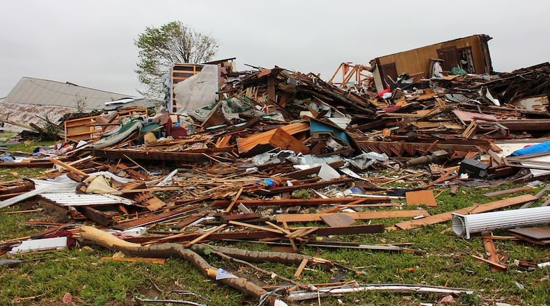
On May 14, 2014, amazingly, no one was killed or injured, but the Dobbins family lost two homes and were trapped in a cellar for nearly 30 minutes while the tornado ravaged the area.
Roger Dobbins, 71, and his daughter's home were destroyed. He said he was watching coverage of the storm on WHIO-TV Channel 7 until his satellite went out at his home in the 4200 block of Barber Road.
"I saw it coming directly toward us," he said. "I could hear a lot of racket. My ears popped."
Dobbins said he and six other people were in the basement: his wife, daughter, a friend of his daughter's, and her three children.
Here's the complete storm report of the path of the tornado as published by the National Weather Service:
The tornado initially touched down in a field just west of
Stringtown Rd. with minor tree damage and roof damage to a home. Damage to a camper occurred. Damage in this area was consistent with wind speeds around 75 mph...EF0 on the damage scale.
The tornado continued across U.S. 35 and Federal Rd. where a farmstead was struck. A barn at this location sustained heavy damage with much of the roof being removed as well as some wall failure. Wind speeds at this location were estimated to be around 85 mph...EF0 on the damage scale.
The tornado then crossed Highway 72 and damaged a property heavily. At this location, several fences and outbuildings were destroyed. The residential home had windows blown out and significant roof damage. Roof damage was also seen on nearby barns. Several large trees on the property were snapped off and broken. A trailer was also tipped over. Wind Speeds at this location were estimated to be around 105 mph...EF1 on the damage scale.
On nearby Turnbull Rd. near a stone quarry, the tornado heavily damaged another property. Here, a detatched garage was destroyed. A small pickup truck was briefly lifted and dragged from its location in the garage to the middle of a field about 75 yards away. Significant roof damage was found to the home at the property with numerous uprooted trees. A lawn tractor was thrown and deposited several hundred yards away. A convergent pattern in the field debris /bean stubble/ just to the south of this property showed the path of the actual tornado. Wind speeds at this location were estimated to be 125 mph...EF2 on the damage scale.
The tornado then crossed the stone quarry and intensified, hitting a farmstead on Barber Rd. directly. Here, there was a complete loss of a residential home built in the 1880's was observed. All exterior walls failed and the home collapsed which led to very little interior wall integrity remaining. A close inspection of the foundation found very little reinforcement for the exterior walls. Healthy hardwood trees were debarked and Reduced to trunks with only stubs of large branches remaining. Several large grain silos were completely lifted and thrown well downstream up to a half mile. Several barns were destroyed. An average of damage indicators at this location suggests a wind speed of 145 mph...EF3 on the damage scale.
The tornado then hit a residence further northeast on Barber Rd. where portions of the exterior walls were removed as well as the roof. Extensive mud spatter covered all four sides of the residence. Wind speeds at this location were estimated to be 135 mph...High-end EF2 on the damage scale.
From there the tornado weakened considerably as it moved parallel to Townsley Rd. and debris from upstream locations covered farm fields as it fell out of the weakening circulation. A barn on Townsley Rd. suffered minor roof damage with winds estimated here at 80 mph...or EF0 on the damage scale.
The tornado crossed Townsley Rd. with a clearly defined scour path through bean and corn stubble. The tornado weakened and lifted very close to the Clark-Greene county line as a little more debris fell out of the rotating storm into extreme southeast portions of Clark county.
About the Author


