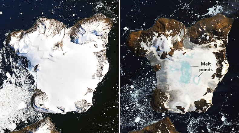
“Around the same temperature as Los Angeles that day,” said NASA.
These warm temperatures arrived around Feb. 5 and lasted through Feb. 13.
RELATED: Cloudy with a Chance of Podcast: Climate Matters
The before and after images were captured by Operational Land Imager (OLI) on Landsat 8. The drastic decrease in ice and snow cover on Eagle Island is clear, not only along the coastline but the bright blue melted ponds in the center of the island.
According to climate models, Eagle Island experienced peak melt—30 millimeters (1 inch)—on Feb. 6.
It’s been estimated that roughly 4 inches of snowpack melted — about a 20 percent loss of seasonal snow accumulation in this one event.
Mauri Pelto, a glaciologist at Nichols College said, “You see these kinds of melt events in Alaska and Greenland, but not usually in Antarctica.”
Pelto stated persistent warmth like this isn’t typical for this part of the world but has become more common in recent years.
“If you think about this one event in February, it isn’t that significant,” said Pelto. “It’s more significant that these events are coming more frequently.”
The heatwave that struck Antarctica was created by a combination of meteorological events. A ridge of high pressure centered over Cape Horn, Chile, allowed warm temperatures to build. Southern hemisphere westerlies typically shield Antarctica from warm air masses, but the winds were weakened allowing the extra-tropical warm air to cross the Southern Ocean and reach the ice sheet.
NASA also believes dry, warm foehn winds could have played a part in the warmer weather, too. Foehn winds are strong, gusty winds that cause downslope windstorms on mountains, often bringing warm air with them.
“In February, westerly winds ran into the Antarctic Peninsula Cordillera,” said NASA.
MORE: Volunteer groups to rebuild damaged tornado homes
Winds may have been forced up the mountains, cooling and condensing releasing heat into the atmosphere. The warmer, drier air then moves down the downslope side of the mountains warming up the other side. Also, the drier air would mean less cloud cover and more sun on the east of the mountain range along the peninsula where Eagle Island is located.
February’s heat is concerning. This was the third major melt event of the Antarctic’s summer, following warm spells in November 2019 and January 2020.
About the Author
