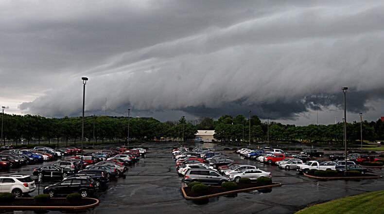
Mean looking shelf cloud moving through @cityofdayton @Kettering_OH #whiowx @whiotv @WHIORadio pic.twitter.com/dubO1fS26S
— Brett Collar WHIO (@BCollarWHIO) June 14, 2017
“Shelf clouds form when a cold downdraft pushes strong winds out ahead of a strong thunderstorm,” according to Storm Center 7 Meteorologist McCall Vrydaghs. “This is known as the gust front. The cool air associated with this downdraft forces warm air up and over.”
RELATED: Track current conditions with Live Doppler 7 Radar
The process creates wedge-shaped appearances. On very humid days the cloud can look ragged and dip low to the ground.
Shelf cloud moving into #Dayton right now! pic.twitter.com/e7B7ewwXrw
— McCall Vrydaghs (@MVrydaghsWHIO) June 14, 2017
“It is important to note these cloud formations are indicative of strong winds,” Vrydaghs said. “You will usually feel a drop in temperature along with increased winds as this cloud and storm approaches.”
The leading edge of the shelf cloud is very close to the ground in @Kettering_OH #whiowx pic.twitter.com/VQj6EaU2lF
— Brett Collar WHIO (@BCollarWHIO) June 14, 2017
Wall clouds, on the other hand, are typically rain-free and will form with a strong updraft of a supercell thunderstorm.
“This rapid rise in air creates a lower pressure below the storms main updraft, forming this wall cloud,” Vrydaghs said. “Sometimes the rotation and vertical motion within this cloud can create a tornado.”
About the Author
